LYNN – The MBTA held an open house discussion regarding the vision for the Lynnway Multimodal Corridor Project on Wednesday.
The project has not yet entered its concept development phase, as the MBTA is currently collecting public feedback, gathering data, and examining existing conditions of the Lynnway.
“Some planning efforts have developed brainstormed ideas of a concept, but none of those are listed as the default. We’re pulling the best ideas we can. We’re listening to feedback, and there’s a lot of the existing conditions. How many cars travel on the roadway? What is the ground survey? What are other projects that need to be coordinated with? We’re getting a variety of different inputs,” MBTA Senior Project Manager Phillip Cherry said during a presentation at Northshore Community College.
The Lynnway project takes place entirely in the city of Lynn. It is approximately 1.6 miles long, stemming from the General Edwards Bridge, running up the Lynnway to Market Street, hanging to the left, and ending at the MBTA busway.
The City of Lynn, MassDOT, and the Department of Conservation and Recreation are also involved in the Lynnway project.
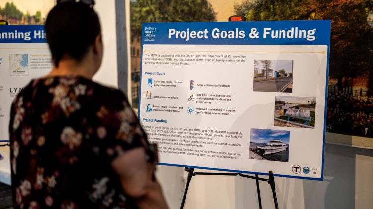
“These agencies have all led to a number of different planning and study efforts over the last four to five years that have pointed to the need for a safer, more connecting, and more multimodal Lynnway,” Cherry said.
In terms of project funding, MassDOT received a grant for $20 million in funding from the U.S. DOT RAISE. The scope of the project provides funding for pedestrian, bus lanes, bike lanes, roadway improvements, traffic signal upgrades, and green infrastructure.
However, the MBTA is not able to access the funds unless it meets certain criteria, so it is currently in the process of advancing the Lynnway project concept so they can do environmental reviews and cost estimations.
“That would be something that we share and apply to get over that final hump to get the funding,” Cherry said.
The National Highway Traffic Safety Administration has concluded that the Lynnway is a “top crash cluster” for motor vehicles, bicycles, and pedestrians, ranking it among the top 200 crash corridors in the state of Massachusetts.
“No matter how you’re traveling here, the data shows that it is not a safe corridor,” Cherry said.
Major concerns surrounding the Lynnway are the narrow sidewalks adjacent to high speeds, congestion, outdated traffic signal hardware, lack of bike facilities between some recreational areas, and the fact that the corridor only has six signalized crossings.
The project is looking at offering households valid options for transportation on the Lynnway that are more than just motor vehicles. According to the MBTA, 19% of Lynn households and 50% of households near the corridor do not own a motor vehicle.
“When you look at those needs, that fed into goals of safer and more frequent pedestrian crossings, a roadway that’s more safe and more calm, transit service that is not only faster and more reliable, but more comfortable,” Cherry said.
Cherry added that the MBTA is also “cognizant” of “large movements” such as tractor trailers that travel the Lynnway.
“We’re doing what we can to make those more predictable and safer for everybody,” Cherry said.
From a transit perspective, there are about 3,000 bus boarding per weekday within the 1.6 mile project limit. This includes the three routes that operate along the Lynnway, and there also transfers to six additional routes at the project’s northern limit, for 70,000 riders per week.
“Many of you may say the bus doesn’t come frequently enough today. The MBTA’s bus network redesign, which is a network wide planning effort to look at how we can increase bus service, has a plan in place for the Lynnway to increase that service every 12 minutes, all day, every day, from the start of service at 5 a.m. or 6 a.m., up to the very end of service,” Cherry said.
He added, “There’s obviously ongoing new development, especially in the southern part of the corridor, so we want to make sure there’s adequate transit to serve the 1300-1500 housing unit range that is there.”
Cherry also emphasized that the MBTA is “very confident” that this project is not expected to be a four-year construction timeline.
“You obviously don’t want to have several miles worth of construction enduring for long periods of time. So we understand the importance of being cognizant of various planning timelines,” Cherry said.
As for the project’s next steps, the MBTA is currently looking to move forward with its concept development phase, which involves implementing ideas and engineering analysis.
Further outreach initiatives include raising awareness through social media and elected officials, pop up events, mail out letters, flyers, office hours, and an online survey.
The online survey is the “general vector for feedback” to “understand what is working and not working,” regarding the current state of the Lynnway. The first half of the survey includes broader questions centered around feelings toward safety on the Lynnway and ranking project goals. The second half of the survey includes more specific questions such as pinpointing congested areas and locating potential areas for pedestrian crosswalks and updated traffic signals.
There has been a “robust” number of 1,300 survey responses, with 50% of the responses from several weeks ago coming from Nahant, Marblehead and Swampscott.
“There have been a broad array of responses throughout the entire area of not only where the project is, but from folks who may drive through the project area,” Cherry said.
The survey is currently slated to close on Sept. 22, but may be extended. After all the survey responses have been recorded, the MBTA will analyze and summarize the feedback, and the analysis will be made public online.
The survey can be found at https://www.mbta.com/projects/lynnway. Questions and comments can be sent to [email protected].